Hydrographic Survey

Hydrographic Survey

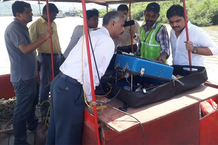
SIEAT provide professional hydrographic, bathymetric and geographical survey services that cover a broad range of hydrographic disciplines.Our Engineers or surveyors have access to a range of hydrographic survey sensors, platforms, state-of-the-art technology and software, enabling us to deliver a unique, tailored data solution to your specific needs. Survey systems are selected based on the scope of work, water depth, operating frequency, range from shore, accuracy requirements, seabed conditions, and size of vessel or boat.Our hydrographic surveyors are all well qualified and experience, making your complete solution for all of your Survey related Work, Survey planning, data acquisition, processing and reporting needs.SIEAT are early adopted of the latest, proven technology, meaning we’ve tried and tested work flows, allowing our surveyors and engineers to work smarter and more efficiently.We’ll advise you on what the best approaches, so we can meet your project’s quality, accuracy, time and cost goals.

Uses of Undertaking Hydrographic Surveys:

Seabed bathymetric surveys and digital terrain models (DTM) for navigation assessment.

Support dredging operations – pre and post surveys, and volume calculations.

Determine sedimentation levels or thickness.

Seabed habitat mapping Geophysical surveying to determine seabed sub-structure and composition.

Seabed sampling and geotechnical analysis.Benefits of Undertaking Hydrographic

Determining seabed form and terrain

Identifying seabed type, features, objects, debris and object detection.

Benefits of Undertaking Hydrographic Surveys are

Determine sedimentation levels or thickness.

Shallow geophysical analysis – 0 to 10m below seabed.

Survey Systems & Solutions Land Surveys Provides

Bathymetric Data Is Used For Range of Purposes Including

Charting and Ship Navigation

Fisheries Management

Environmental Management, Including Establishing Baseline Data to Support Environmental Monitoring

Determination of Maritime Boundaries

Alternative Energy Assessments (I.E. To Support Offshore Wind and Wave Energy Assessments)

Research into Coastal Processes and Ocean Currents, For Example Tsunami Modelling

Assessment of Environmental Considerations for Marine Geology Resource Management Including the Identification of Geohazards, Such as Underwater Landslides

Talk to us

Have any questions? We are always open to talk about your business, new projects, creative opportunities and how we can help you.

Our Other Services

Topography Survey

Drone Survey

Road & Rail Survey

Cadestral Survey

GPR Survey

Property & Boundary Survey

Our Partners